
Aneto Glacier in the Pyrenees of Spain is listed as its largest glacier in a 1984 inventory. In 1984 the glacier had an area of 1.32 square kilometers and a length of 1.6 km (Serrat and Ventura, 2005). The glacier is located on the northeast side of Aneto Peak. The glacier is just a few kilometers from the rapidly retreating Maladeta Glacier. SOER (2010) indicate that more than 80% of the glacier area on the Maladeta-Aneto Massif was lost between 1984 and 2007.

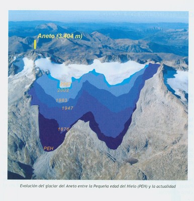
Image from SOER (2010)
The glacier is too small to rely on our usual Landsat imagery. Here we focus on images from Google Earth and the Digital Globe. The glacier’s maximum top to bottom length by 2005 is no more than 600 meters, black dots indicate glaciers lower margin. The area in 2007 is 0.4 square kilometers by which time the glacier has developed a number of rock outcrops protruding through the thin ice. Snowcover in most images by late summer is minimal. This indicates the lack of a consistent accumulation zone, which a glacier cannot survive without (Pelto, 2010). The glacier has many exposed annual layers extending well upglacier, this is a further indication of the poor preservation of even old glacier ice. In 2005 and 2007 less than 10% of the glacier is snowcovered in the images which are not even at the end of the summer. This glacier is disappearing and like the Careser Glacier, Italy will break into several parts. The thin nature of the glacier is evident by looking up glacier from the terminus, last image from Gus Llobet (llobetgus-on Panaramio)

2005 Google Earth image, limited snowcover evident

Arrows indicate rock outcrops amidst the glacier.

2007 Digital Globe image
Annual layers of main glacier trunk in 2007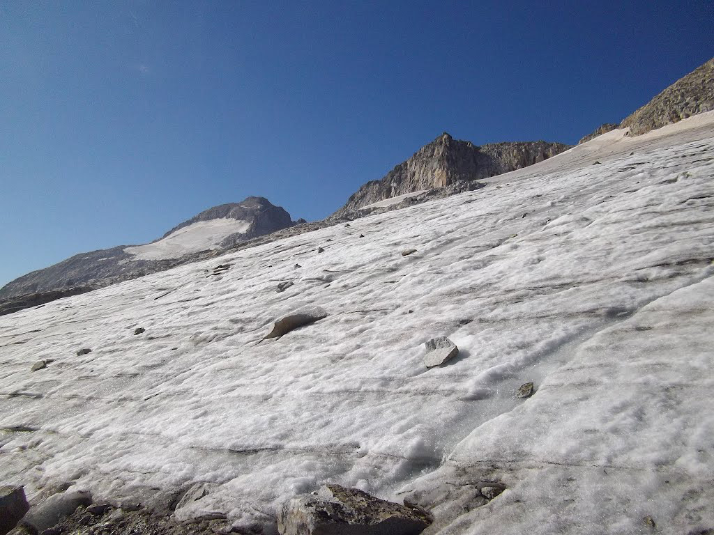
Images from Panaramio user-llobetgus

Hello Mauri, just did some quick “Google research”, another 5 – 10 years, the Aneto Glacier is history I am afraid.
I have not seen what the glacier looks like in 2013, however, I do not think it will be that soon. There are two areas where the glacier is still 600 m long, and likely over 50 m thick in both.
There will not be that much volume left to qualify it to be real glacier, movement etc.?
The minimum qualifications to be a glacier are not well defined and typically an area of 0.1 square kilometer is a glacier, with some research getting carried away and measuring down to 0.01 square kilometers
Prof. Pelto: This is off topic, but the phenomenon is so strange that i thought to ask you. Mr. Wipneus has posted some images of Zachariae at the arctic sea ice forum. The amazing thing is
that boulders move but the lakes do not. How can this be ?
“Look at the glacial lakes, they stay in the same place while the local ice is moving.”
sidd
I will look this weekend, post comment at
https://glacierchange.wordpress.com/2012/08/27/zachariae-isstrom-further-retreat-ne-greenland/
Post this in Zachariae Post, and I will look this weekend.
https://glacierchange.wordpress.com/2012/08/27/zachariae-isstrom-further-retreat-ne-greenland/
Unfortunately it says comments are closed on the Zachariae entry.
I enclose a link to the Wipneus post here:
https://forum.arctic-sea-ice.net/index.php/topic,400.msg24431.html#msg24431
i think the answer may be that the lakes reform in the same place year after year. Could the depressions they form in be a feature of the flow like stationary ripples in a stream ?
sidd
Pingback: Another Week of Climate Disruption News, April 20, 2014 – A Few Things Ill Considered
Pingback: Another Week of Climate Disruption News, April 20, 2014 [A Few Things Ill Considered] | Gaia Gazette
Pingback: Portillon Glacier, French Pyrenees- Retreating and Disappearing | From a Glaciers Perspective