
Meade Glacier drains the northwest portion of the Juneau Icefield, with meltwater entering the Katzehin River and then Chilkoot Inlet. The glacier begins in British Columbia and ends in Alaska. Here we use Landsat imagery to examine changes in the glacier from 1984 to 2014. The glacier experienced a slow continuous retreat from 1948 to 1986 of 400 m, the glacier ended on an outwash plain. From 1991-2006 JAXA’s EROC program noted a retreat of 570 m, retreating into a lake basin. In 2007 the lower 2.5 km of the glacier was stagnant and heavily crevasses, poised for collapse in a developing proglacial lake. The 1948 map of the glacier indicates no proglacial lake with the glacier terminating on an outwash plain.

USGS Topographic map from 1948 aerial photographs
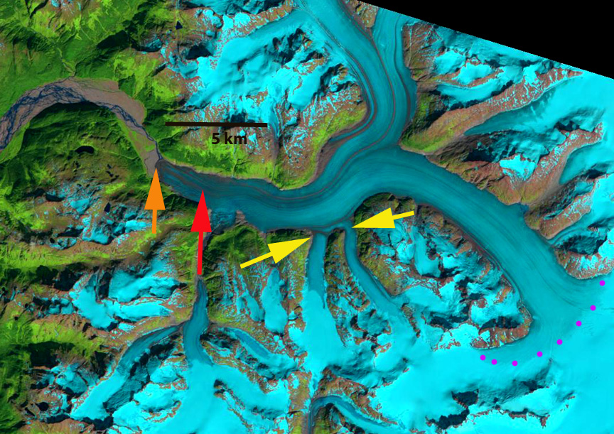
In 1986 the terminus is indicated by an orange arrow, the 2014 terminus by a red arrow, two tributaries that connect to the Meade Glacier are indicated by yellow arrows and the snowline at is indicated by purple dots. The snowline is at 1250 m in 1986, there is no evident lake at the terminus of glacier just an expanding outwash plain. Both tributaries are 750 m+ wide where they join Meade Glacier. By 2004 a 400 m long proglacial lake has formed at the terminus. The two tributaries from the south at the yellow arrows no longer are connected to the glacier. The snowline is at 1450-1500 m, which is much higher than in 2004 on Taku Glacier or Brady Glacier. In 2009 the snowline is at 1400 m, the proglacial lake has expanded to 600 m in length. In 2014 the proglacial lake is 3.5 km long, the entire lower 2.5 km of the glacier has collapsed since 2007. There is still considerable relict ice floating in the lake. There is a substantial lake along the southern margin of the glacier where a tributary streams enters the main valley. This indicates the glacier will quickly retreat to this point by further collapse into the lake. The snowline in 2013 and 2014 was quite high and the summer’s quite warm which aided in the lake expansion. The snowline in 2014 is at 1400 m on Aug. 2, the date of the imagery, the high snowlines ensure continued mass loss and glacier retreat. There was still six week of summer melting remaining on the date of the imagery. The Meade Glacier is poised to continue a rapid retreat in the near future its retreat parallels that of most Juneau Icefield glaciers including the next glaciers to the south Field Glacier and Gilkey Glacier.
1986 Landsat image

2004 Landsat image

2009 Landsat image

2014 Landsat Image
