Anderson Glacier, Olympic Mountains, Washington Disappears

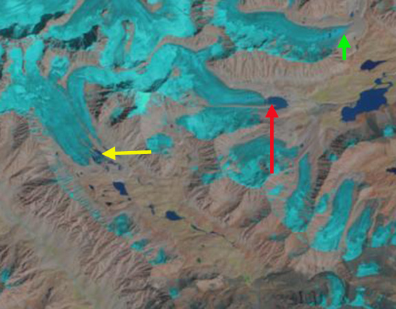
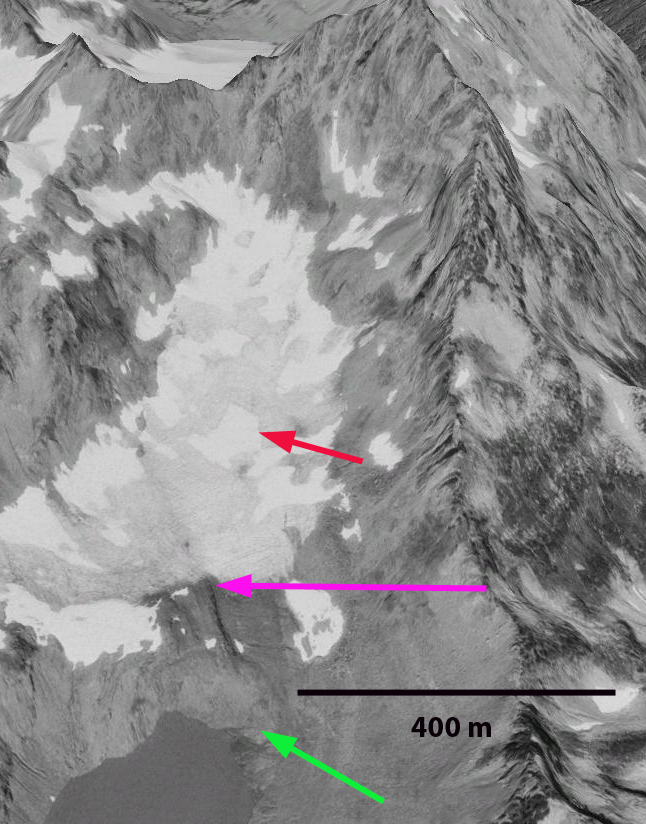
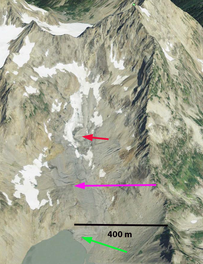
Anderson Glacier was the headwaters of the Quinault River in the Olympic Mountains of Washington. A century ago the glacier was 2 km long, and a half kilometer wide. Retreat of this glacier in the first half of the 20th century exposed a new alpine lake as the glacier retreated 1 kilometer. From 1950-1980 the glacier diminished slowly. From 1959 to 1990 the glacier thinned and retreated from the shore of the lake trapped behind the Little Ice Age moraine. The 1959 picture below was donated to me by Austin Post. Since 1990 the glacier has begun to shrink rapidly. The Google Earth image from 1990, indicates Anderson Glacier has retreated 200 m from the 1959 terminus position near the lake shore, green arrow to the 1990 position, pink arrow. The red arrow indicates a future location of a bedrock outcrop.
1959 Austin Post image
anderson Glacier 1990
1990 Google Earth image

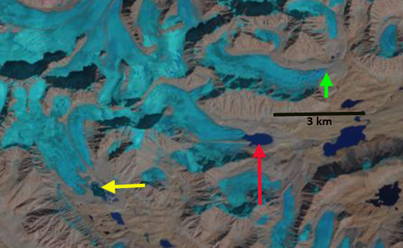
Investigating this glacier in 1992 we measured its area at 0.38 square kilometers, down from 1.15 square kilometers a century before. Ten years later the glacier had diminished to 0.28 square kilometers, but had thinned even more, leaving it poised for a spectacular change, over the next five years. Large outcrops of rock appeared beginning in 2003 and further exposed in 2005 and 2007 in the middle of the glacier. Note the outcrops in the 2007 image from Kathy Chrestensen. The 2009 Google Earth image indicates the 1990 terminus position, pink arrow, and the fact that there is no longer a ribbon of snow that is even 50 m wide. The snow patches have insufficient size or thickness to be classified as a glacier.  The largest outcrop at the red arrow had been beneath the ice in 1990, giving a scale to the thinning.  The glacier at this point no longer exists. In 2014 an Eric Hovden image indicates some seasonal snow in the basin, but the thin ribbon of snow has numerous holes in it as well, indicating the thin nature of the remaining snow patches, with a month left in the 2014 melt season.

Kathy Chrestensen Image

anderson glacier 2009
2009 Google Earth Image

anderson glacier 2014
2014 Eric Hovden image.

This glacier had become a series of small disconnected relict glacier ice patches in 2005 and by 2009 had disappeared. It is not the only glacier that is disappearing, which has led to a visual model for forecasting glacier survival (Pelto, 2010). The key is observed retreat of the margin of the upper portion of the glacier and emerging rock outcrops in the upper part of the glacier where snow should accumulate and be retained through the melt season. If a glacier does not have a significant persistent accumulation zone it cannot survive. Anderson Glacier was not the only glacier feeding the Quinault River, all the others are retreating as well. The result of this glacier retreat is reduced late summer and early fall streamflow, impacting salmon runs at that time of the year. This is primarily the fall Coho, Chum and Chinook salmon and Steelhead summer run. During the spring and early summer runoff increases as snowmelt still occurs, but is not retained in the glacier system.To get a sense of the special nature of this area Out of the Mist is an excellent start

Tchap Dara Valley Glacier Retreat, Afghanistan

The Wakhan Corridor in Afghanistan is quite remote. A look at maps or Google Earth will indicate the lack of even place names except in the main river valleys. The Secret Compass uses this fact to advantage for expeditions in the region. Here we examine three glaciers north of Sarhad two draining into the Tchap Dara Valley. Haritashiya et al (2009) examined fluctuations of 30 Wakhan Cooridor glaciers from 1976-2003. They found that 28 of the glaciers had retreated.
Here we examine Landsat images from 1998, 2002 and 2013 with the green arrows pointing the 2013 terminus position of the northern glacier, the red arrows to the 1998 terminus position of the center glacier and the yellow arrows indicating the 1998 terminus location of the western glacier. The blue arrows indicate ice flow.Tchap dara ge
Google Earth image

In 1998 the red arrow indicates the terminus of the center glacier, which also has an ice cored medial moraine that extends nearly across the entire proglacial lake that the glacier terminates in. The northern glacier extends beyond the green arrow. The western glacier extends to the yellow arrow filling much of a small basin. In 2002 there is little evident change at the northern glacier. The center glacier has retreated leading to lake expansion, and the medial moraine extending into the lake is also shorter. The western glacier no longer reaches the yellow arrow. By 2013 the northern glacier has retreated 200 meters to the green arrow. The center glacier has retreated 400 m leading to the same amount of lake expansion, the medial moraine no longer extends into the main lake basin. The western glacier no longer reaches a lake that has developed in the basin at the 1998 terminus position. The retreat is 300-400 meters. The retreat over 15 years is substantial for small glacier like this. This parallels the retreat at nearby Zemestan Glacier and the Emend River headwaters glaciers.tchap Dara 2013
1998 Landsat image

tchap dara 2002
2002 Landsat image

tchap dara 2014
2013 landsat image

Rainbow Glacier: Record Ablation in 2014 for 1984-2014 Period

From 1984-2014 we have monitored the mass balance of the Rainbow Glacier on Mount Baker, North Cascade Range, Washington. This entails detailed monitoring of snowpack depth in July and August, and subsequent ablation to the end of the melt season. On July 13th the glacier was completely snowcovered. By August 10th the snowline had risen to 1575 m, with 1.4 m of ablation since July 13th. We measured the snowdepth at 85 locations on the glacier, with only 6 measurements exceeding 3.5 m on Aug. 10th.

Ben Pelto and Ashley Edwards examining crevasse stratigraphy both the 2013 and 2014 layers evident.

Limited snowpack below the main icefall at 1750 m on Aug. 10.

Minimal 2014 snowpack in crevasses at 1650 m on Aug. 10th 1.25 m.
Limited snowpack below the main icefall at 1750 m on Aug. 10.
By September 27th the snowline had risen to 1975 m with a few pockets of snow retained where the snowdepth had exceeded 3.2 m on Aug. 10th. Snowdepth at the Sept. 27th snowline had been 3.0 to 3.2 m on Aug. 10th. This indicated ablation of approximately 3 m of snowpack, 1.8 m of water equivalent from Aug. 10th to Sept. 27th. Ablation from July 13th to Sept. 27th was 5.3 m of snowpack and 3.2 m w.e. This was 5-10% more ablation than any other year since 1984. A comparison of images from the ground on Aug. 10th indicates the snowpack on the glacier from 1550-1950 m, the blue arrows indicate locations where a patch of 2014 snow remained on Sept. 27th. The Sept. 27th image was taken by Tom Hammond from Rainbow Ridge the only location where the whole glacier can be viewed. The firn is simply old snow that survived a summer and could be from 2012 or 2013.
Aug. 10th accumulation zone view

Tom Hammond Image adusted to show firn, ice and retained snow. Sept. 27th

Winter snowpack was normal on Mount Baker, the record ablation then led to a large negative mass balance for the glacier of -1.8 m, but not a record loss. The ablation did lead to many significant surface streams on the glacier shown below, which drain into the glacier at moulins.

The terminus of glacier retreated rapidly from 1984 to 1998, but has slowed as it currently is in an avalanche runout zone. We visited the terminus in 1984 and all retreat is measured from that point when the glacier was in contact with an advance moraine from the 1955-1980 period of advance. A comparison of 1993 and 2006 Google Earth images indicates the retreat, red outline 2006 margin and black outline 1993. The 2014 image taken by Tom Hammond indicates that the terminus did get exposed in 2014 which will lead to additional retreat when we measure the terminus position next summer. Total retreat from 1984 to 2014 is 490 m.

1993 Google Earth view of terminus

2006 Google Earth view of terminus.
Picture of the terminus in 2014 indicating the 214 and 1984 position.  Taken by Tom Hammond from Rainbow Ridge.
Picture of the terminus in 2014 indicating the 214 and 1984 position. Taken by Tom Hammond from Rainbow Ridge.
Ablation zone on Aug. 10

Yajun Peak Glacier Retreat, Afghanistan

Glaciers of Afghanistan have received little detailed attention for obvious reasons, only satellite image analysis of selected areas has been completed Haritashiya et al (2009) and Shroder and Bishop (2010), both studies noting a significant retreat and downwasting. In this post glaciers in the remote area around Yajun Peak in the Hindu Kush 150 km northeast of Bagram Airbase and 75 km west of the Pakistan Border are examined. Landsat imagery from 1998 (1st image below), 2010 (2nd image below) and 2012 (3rd image below) are used in combination with 2008 Google Earth imager (Last image below). Changes in three glaciers on Yajun Peak (6024 m) are highlighted. The yellow arrows indicate the expansion of bare rock amid a glacier draining south from Yajun Peak. The expansion of the bare rock area from the terminus area in 1998 to 2012 is evident as is the expanded area of the ridge in the upper glacier noted by the yellow arrow in each image. The magenta arrows indicate the terminus of a glacier draining west from Yajun Peak that in 1998 did not have a lake at the terminus. In the 2008, 2010 and 2012 imagery a small lake has developed as the glacier has thinned and retreated. The third glacier flows northwest and terminates in 1998 at a green line that is a one kilometer long line between two specific topographic points in each image. The glacier has retreated from the green line by 2008 and the retreat is 125 meters by 2012. In the 2008 Google Earth image a purple arrow points out the upper basin of a fourth glacier that is no longer ice or even snow filled. This along with the expansion of the bedrock ridge near the top of the glacier with yellow arrows indicates that even the accumulation zone of these glaciers are not persistently snow covered. Glaciers that lack a persistent snowcover cannot survive (Pelto, 2010). To see the details just click on each image and an expanded version will appear.
In previous posts on glaciers in the region the Emend Watershed and Zemestan Glacier the retreat is similar.

Emend River Headwaters Glacier Retreat, Hindu Kush, Takhar Province, Afghanistan

The Emend River drains from the Hindu Kush Mountains and joins the Worsaj River and eventually drains into the Amu Darya River. This area is not impacted much by the summer monsoon and glacier runoff is key to summer streamflow. The runoff from the glacier is tapped for extensive irrigation in the valley bottom both along the Emend, and eventually downstream near Taliquan (bottom image). At the headwaters of the Emend River, Takhar Province, Afghanistan are a pair of 3 kilometer long glaciers that are the focus of this post. We examine Landsat images from 2000 and 2011 and a Google Earth image from 2004. In 2000 the western glacier ends in a proglacial lake indicated by the purple arrow in each image. By 2007 the glacier has receded 50 meters from the edge of this lake, and by 2011 the glacier has receded 100+ m from the lake. On the eastern glacier in 2000 a small proglacial lake less than 0.1 square kilometer is at the end of the lake, yellow arrow. In the 2007 Google Earth image the lake has expanded as the glacier has retreated and has an area of 0.25 square kilometers. A small additional expansion has occurred by 2011, with the lake area reaching 0.3 square kilometers. Another glacier to the south also in the Emend River watershed has also experienced lake expansion at its terminus, red arrow. This latter lake has expanded from less than 0.1 square kilometers to 0.3 square kilometers in the last decade. These are all small lakes and do not pose a glacier lake outburst flood hazard.
<

A closeup view of the terminus area indicates numerous depressions, green arrows. The depressions are ablation hollows, where more dust has accumulated, and then accentuated ablation, the hollows typically form from wind scouring. The hollows are not water filled, Petrov Glacier also featured similar features. This region of the Hindu Kush has not been the focus of detailed glacier studies. Northeast of Takhar Province in the Wakhan Corridor a group of glaciers was examined by Umesh Haritashya and others (2009) and found 28 of thirty had retreated. Zemestan Glacier is one example. The Hindu Kush follows the pattern of the high mountains of central Asia including the Himalaya.

Zemestan Glacier, Afghanistan Retreats

The Wakhan Corridor in Afghanistan is not easy to get to, as a result field study of its glaciers are quite limited. This is where the Global land ice Monitoring System (GLIMS) comes in. GLIMS acquires satellite imagery of glaciated areas, making these images available to researchers and processing them to an extent for inventory purposes. GLIMS is led by Jeff Kargel at the University of Arizona. In the Wakhan Corridor a group of glaciers was examined by Umesh Haritashya and others (2009). This recent GLIMS project examined ASTER and Landsat MSS data 1976–2003, in the Wakhan Corridor of Afghanistan. Of the 30 alpine glaciers of varying type, size and orientation examined 28 glacier-terminus positions have retreated, two have been stationary. The largest average retreat rate was 36 m per year, and the average retreat was 11 m per year. The retreat is evident in a comparison of 1998 Landsat and 2010 Landsat images, note the orange arrow in both. The width and length of the terminus tongue has changed. One of the glacier examined was the Zemestan Glacier. This glacier is 5.3 kilometers long, has an area of 5.2 square kilometers, begins at 5640 meters and terminates at 4800 meters. It is one of many glacier in the Central area of the Wakhan Corridor. Zemestan Glacier has retreated at a rate of 17 meters per year over the study period, a total retreat of 460 meters, 9% of its total length. A comparison of 1998 and 2010 Landsat imagery indicates the retreat of the terminus tongue in width and length at the orange arrows. The glacier has remained snowcovered at its higher elevations at the end of the summer in recent satellite images. This indicates that with current climate the glacier does have a significant accumulation zone and can survive current climate. Continued warming will increase the retreat rate and could threaten its survival. The glacier feeds the Pamir River which in turn drains into the Panj River, to the Amu Darya River and then the Aral Sea. The terminus is on a shallow slope lacks a steep slope and is not extensively crevassed. All of these factors indicate retreat will continue. The glacier has little debris cover unlike many glaciers in the Karakoram-Himalaya-Pamir Ranges such as the Khumbu Glacier or the Zemu Glacier